
Bhubaneswar: Several parts of Odisha are likely to be lashed by heavy rain till the morning of August 21 amid a low pressure area over the Bay of Bengal, the India Meteorological Department (IMD) said on Saturday.
In a midday bulletin, the Meteorological Centre in Bhubaneswar said the low pressure area now lies over south Bangladesh & neighbourhood. The associated cyclonic circulation extends up to 7.6 km above mean sea level tilting southwestwards with height.
The system is likely to move slowly north-northwestwards and become a well-marked low pressure area over Bangladesh and adjoining Gangetic West Bengal by August 19.
Thereafter, it is likely to move west-northwestwards across Gangetic West Bengal, Jharkhand & adjoining Bihar and Uttar Pradesh & adjoining Madhya Pradesh during subsequent 3-4 days.
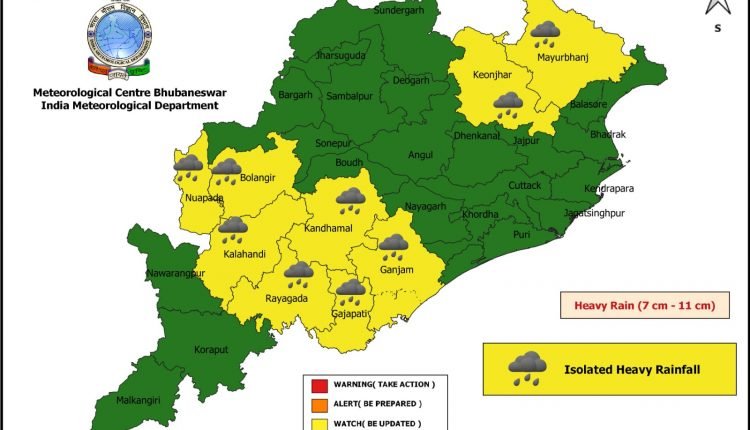
The weather agency issued yellow warning of heavy rain (7 to 11cm) at one or two places of Balangir, Kalahandi, Rayagada, Gajapati, Ganjam, Kandhamal, Nuapada, Mayurbhanj, and Keonjhar during the next 24 hours.
Aug 18
Yellow Warning: Heavy rain (7 to 11cm) may occur at one or two places over the districts of Mayurbhanj, Keonjhar, Sundargarh, Deogarh, Sambalpur, and Jharsuguda
Aug 19
Yellow Warning: Heavy rain (7 to 11cm) is likely to occur at one or two places over the districts of Keonjhar, Sundargarh, Deogarh, Sambalpur, Jharsuguda, and Bargarh.
Aug 20
Yellow Warning: Heavy rain (7 to 11cm) is likely to occur at one or two places over the districts of Sundargarh, Jharsuguda, Sambalpur, and Bargarh.
Comments are closed, but trackbacks and pingbacks are open.